Could the coldest and cruelest days of winter be behind us?
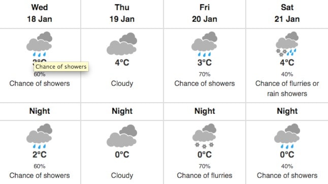
Temperatures forecasted for Kelowna in the week ahead look downright balmy, when compared to the period that passed. Environment Canada is calling for flurries and temperatures near freezing for the first part of the week, but by Wednesday there's going to be a turnaround.
Rain is expected to roll in, while temperatures reaching back into the plus side of the thermometer. A reading of 3 C to 4 C are expected to be standard until the end of the week, with the low temperature going only to 0C.
While things are looking up locally, it's not all sun hats and light sweaters everywhere.
If you're headed to Alberta you need to be very wary of winter.
Environment Canada has issued a snow warning for the Trans-Canada, Eagle Pass to Rogers Pass.
Snowfall, with total amounts of about 25 cm is expected.
Snow will begin near noon today across Rogers Pass as a series of Pacific fronts move across the region.
"The snow will intensify Monday and likely persist through Tuesday. Snowfall accumulations of up to 25 cm can be expected by Tuesday morning," reads the report.
"Visibility may be suddenly reduced at times in heavy snow. Surfaces such as highways, roads, walkways and parking lots may become difficult to navigate due to accumulating snow."
ShiftIntoWinter.ca reminds drivers to know before you go. Adjust to winter driving behaviour and use winter tires and chains.
Road conditions are available at www.drivebc.ca.Continue to monitor alerts and forecasts issued by Environment Canada. To report severe weather, send an email to ec.tempetepacifique-pacificstorm.ec@canada.ca or tweet reports to #BCStorm.