UPDATE Wednesday, 4 p.m.
The Whip Creek and the Smyth Creek fires near Mabel Lake have burned together.
“From this point forward, these fires will be managed together as one under the name Whip Creek,” the B.C. Wildfire Service reports.“Currently, the Whip Creek fire is being resourced and actioned.”
The fire, estimated at 173 hectares, is not threatening any structures at this time.
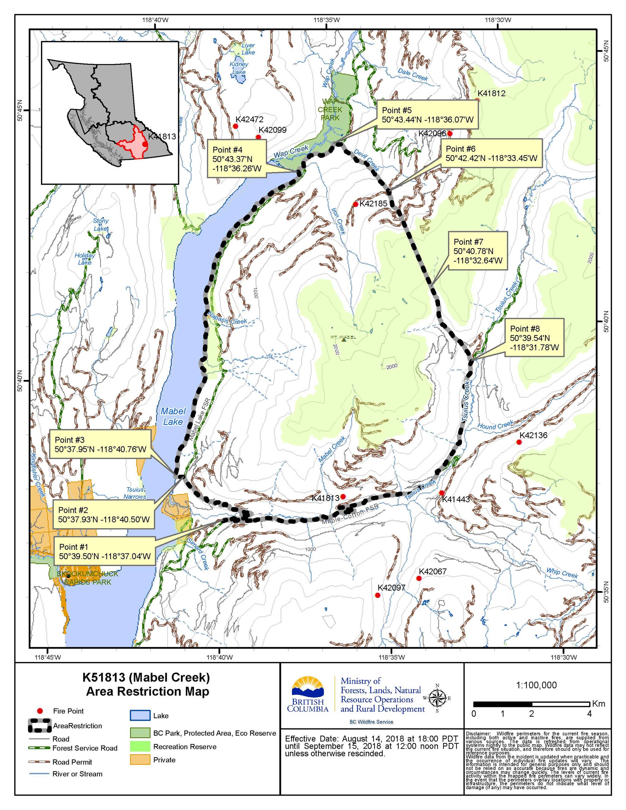
But area restrictions have been expanded to encompass the area of the Whip Creek fire. Restrictions have also expanded northwest of SugarLake.
See: B.C. declares state of emergency as more than 560 wildfires rage
The remainder of the fires burning in the Monashee Complex are either full response monitor-only fires or as full response - modified fires.
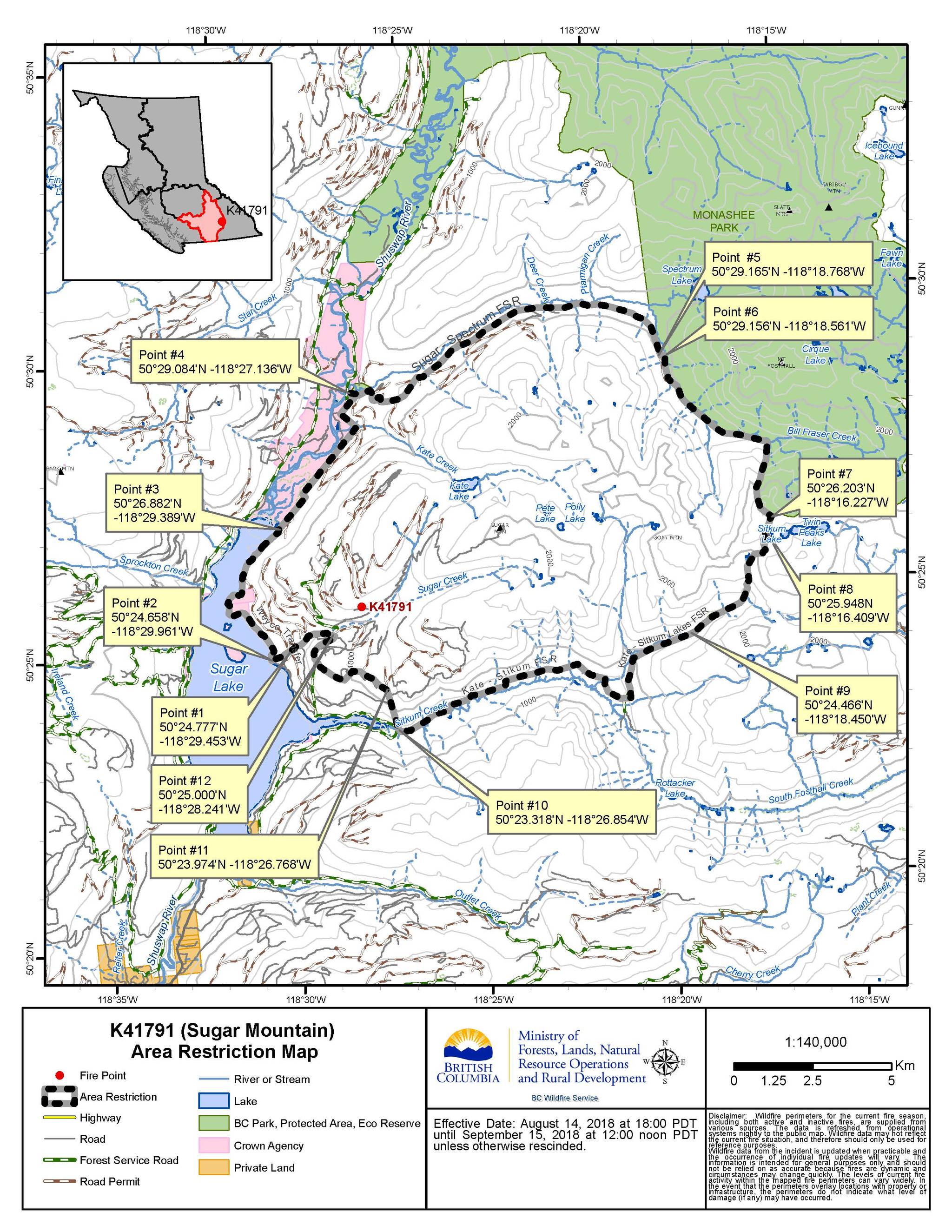
Priority continues to be given to the fires of note: Mabel Creek, Sugar Mountain and Harris Creek.
Meanwhile the forecast isn’t favourable for the fires.
A ridge is currently rebuilding, which could bring higher temperatures and lower humidity values.
“We are expecting to see an increase in fire behaviour later this week and are strategizing accordingly,” BCWS states. “There may even be somelightning holdovers from Saturday’s storm in the area that could flare up later this week.”
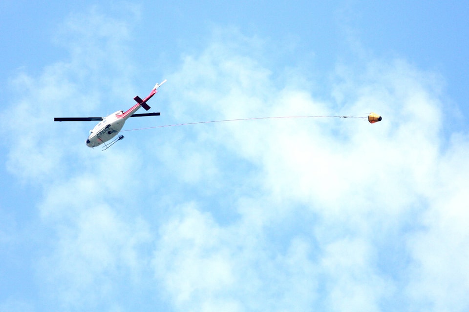
Smoky conditions have also proven challenging, but an anticipated increased visibility Wednesday was hoped to allow for increased firesuppression as well as the opportunity to fly rotary aircraft.
See: Okanagan air quality at a high health risk
……………..
UPDATE Tuesday 7:30 p.m.
The BC Wildfire Service has released their Tuesday evening update for the Monashee Complex wildfires.
The provincial firefighting service reports none of the three major fires in the region have grown in size today.
The Mabel Creek wildfire is still pegged at 1,861 hectares and remains classified as out of control.
Both the Sugar Mountain and Harris Creek fires are holding at 332 and 508 hectares respectively.
The Monashee Complex refers to the fires burning in the drainages of Mabel and Sugar lakes, from just south of Highway 6 in the south to Three Valley Gap in the north.
The largest challenge crews are facing is danger trees.
The trees in the video (below) are cedar, which burn from the inside out, until they fall without warning.
“The safety of our workers is our absolute top priority. The operations team has had to pull crews off of areas of the Devil’s Creek fire because of the hazard danger trees present,” BC Wildfire Service states.
Twelve Danger Tree Assessors/Danger Tree Fallers have been contracted on to this complex to help mitigate the risk of danger trees to firefighters.
—-
UPDATE: Tuesday 10 a.m.
There are now 27 wildfires burning in the North Okanagan.
The Monashee Complex refers to these fires burning in the drainages of Mabel and Sugar lakes from just south of Highway 6in the south toThree Valley Gap in the north.
There are three fires of note being prioritized: Mabel Creek (1,861 hectares), Sugar Mountain (332 hectares) and Harris Creek (508 hectares).
The remainder of the fires burning in the Monashee Complex are in modified response or are being monitored and assessed. The following isa list of those burning in the North Okanagan region.
- Procter Road (Lumby) 25.5, no longer a fire of note and is being held
- Finlyson Lakes (Mabel) 16
- Smyth Creek (Mabel) 40
- Whip Creek (Mabel) 133.6
- Hound Creek (east of Mabel) .1
- Devil Creek (Mabel) 35
- Derry Drainage (north of Mabel) 31
- North tip of Mabel Lake 1.2
- Sprokton Creek (Sugar Lake) .01
- Spectrum Creek (north of Sugar Lake) .01
- East of Tsuius Mountain 4.8
A camp has been set up five kilometres east of Lumby on Highway 6 to serve the Monashee complex of wildfires. There are also eighthelicopters in the area.
“We did get some rain out on the fires but the rainfall amounts are pretty variable,” said Kim Weir, fire information officer. “We saw as little astwo mm of rain in the south end and reports of 12 mm of rain in the north end. The little bit of rain that we did get will lower fire behaviourbut we are looking at sunnier skies and warmer days. So we are expecting some increased fire behaviour.”
“But the cooler weather has given us a little bit of reprieve.”
Meanwhile the heavy smoke in the area has limited aircraft operation as helicopters aren’t always able to fly.
An air quality advisory remains for the region, although conditions have improved considerably from Monday’s highest risk rating of 10 for the area. Tuesday saw the index drop to six, or moderate for the North Okanagan.
See: Okanagan air quality improves slightly
Men’s 45+ soccer games were postponed throughout the valley due to the poor air quality Monday night.
The weekend’s storms also brought lightning, which sparked a number of new blazes within the area.
Lumby firefighters were called to a lighting fire Saturday morning on Riggins Road (out Mabel Lake Road).
“Pretty minor, a single tree the actual residents of the property it’s on got it knocked down before our guys got there,” said Fire Chief TonyClayton.
Recreation site and road closures remain in effect near the Mabel and Sugar fires. But there is some concern that these closures are not beingrespected by the public. Therefore security is being brought in to help turn people away from the area
“It (Mabel Lake Road) is a gnarly road, single lane,” said Weir. “We’ve seen some dangerous situations out there.”
See: Motorists urged to steer clear of Mabel forest road due to wildfires
UPDATE: Monday 7:20 p.m.
There has been no growth on the Monashee Complex wildfires, Monday, burning near Lumby and Cherryville.
The Mabel Creek, Sugar Mountain and Harris Creek fires continue to be the priority fires of note in the complex of wildfires that includes 27 blazes in the drainages of Mabel and Sugar lakes from just south of Highway 6 in the south to Three Valley Gap in the north.
The blazes at Mabel Creek remain at 1,861 hectares, Sugar Mountain at 332 hectares and Harris Creek at 508 hectares.
According to BC Wildfire, today’s objectives include building machine guard and hand guard in areas we are unable to reach with machines, reinforcing and patrolling the guard already in place, and generally progressing toward containment.
Previously the Mable Creek blaze grew to the west and joined with several smaller fires.
————
UPDATE MONDAY 11 a.m.
Despite all the rain that dampened the area over the weekend, fires continue to flare near Lumby and Cherryville.
A camp is being set up five kilometres east of Lumby on Highway 6 today and should be operational by this evening. It will serve the Monashee complex of wildfires, largely: Mabel Creek (1,861 hectares), Sugar Mountain (332 hectares) and Harris Creek (508 hectares) fires.
“We did get some rain out on the fires but the rainfall amounts are pretty variable,” said Kim Weir, fire information officer. “We saw as little as two mm of rain in the south end and reports of 12 mm of rain in the north end. The little bit of rain that we did get will lower fire behaviour but we are looking at sunnier skies and warmer days. So we are expecting some increased fire behaviour.”
“But the cooler weather has given us a little bit of reprieve.”
Meanwhile the heavy smoke in the area has limited aircraft operation as helicopters aren’t always able to fly.
See related: Okanagan air quality index poor due to smoke
But with the rain storms came a lot of lightning.
“That definitely may have caused new starts that we may not see today,” said Weir.
There are eight helicopters in the area able to action these and the existing wildfires of note.
“We don’t expect that any grew over the weekend significantly,” said Weir.
Recreation site and road closures remain in effect near the Mabel and Sugar fires. But there is some concern that these closures are not being respected by the public. Therefore security is being brought in to help turn people away from the area
“It (Mabel Lake Road) is a gnarly road, single lane,” said Weir. “We’ve seen some dangerous situations out there.”
There are 10 firefighters actioning the Mabel Creek fire along with two danger tree assessors and fallers and eight pieces of heavy equipment on site. Tolko Industries Ltd. have also assigned heavy equipment and personnel on these fires.
“They’re still trying to establish guards on the west flank to limit growth,” said Weir, as the fire grew to west past Mabel Creek and has joined with four smaller fires to the north.
At Sugar Mountain, there is a Tolko equipment task force team including personnel and 11 pieces of heavy equipment working on the suppression of this fire.
“Crews have completed the east guard and the west guard and now working on the north end,” said Weir.
Harris Creek has 26 firefighters and eight pieces of heavy equipment.
“The good news about that one is a containment line has been completed around a large portion of the fire,” said Weir.
The Procter Road fire (25.5 hectares) is no longer classified as a wildfire of note. Therefore a final update Saturday listed the fire as being held, approximately 16 kilometres northeast of Lumby.
Across the Kamloops Fire Centre, the BC Wildfire Service estimates 55 new fires were sparked by lightning over the weekend. Approximately 240 were sparked B.C. wide.
That has led to greater demands on already stretched and limited resources. There is a potential for resources to be coming from eastern Canada.
With the thick smoke covering much of the province, air tankers have also been grounded.
UPDATE SUNDAY 3:30 P.M.
Campsite and road closures remain in place as increased wildfire activity picks up near Lumby and Cherryville.
BC Wildfire Service has recommended the closure of the recreation site near the northeast corner of Sugar Lake along with the Kate Creek forest service road access road. Kate Creek and Sugar Mountain lookout are both listed as closed.
A closure of all recreational traffic on Mabel Lake forest service road from the eight-kilometre mark to 59 is in place, along with all recreation sites along that road.
This does not affect the Mabel Lake provincial campground but does affect Cascade Beach, Cascade Falls, Cottonwood Beach and Napasis Creek. The closure also does not apply to the residents in the Mabel Lake Holdings community, nor other private residences along the road.
The Monashee Complex, which refers to multiple fires in the drainages of Mabel & Sugar lakes from #BCHwy6 in the south to Three Valley Gap in the north, saw high fire activity yesterday. Most notably the Mabel Creek #BCwildfire ~6.5 km east of Mabel Lake is been mapped at 1861 ha pic.twitter.com/ha1GGd34Mx
— BC Wildfire Service (@BCGovFireInfo) August 11, 2018
“These closures are not due to fire threat but for road safety for our crews and industry partners travelling to and from the fires,” the notice states. “This takes effect immediately.”
A fire camp is expected to be set up Sunday east of Lumby.
“Yesterday there was extreme fire behaviour within those fires,” said Rosalie MacAulay, fire information officer. “This is a result of the ongoing high temperatures and low humidity.”
Mabel saw additional growth on the western flank.
The Harris Creek fire also caused some challenges.
“They have a spot on the western guard that has been causing them some problems,” said MacAulay.
As of Sunday morning, this fire, located approximately 16km from Lumby, is about 508 hectares in size and is still classified as out of control. Resources include 24 firefighters, eight helicopters and heavy equipment.
A unit crew and a contract crew are working alongside industry personnel and equipment. B.C. Wildfires said they have completed a wide containment line around the fire, allowing the option to burn to the guard and limit the spread to the west into a slide area and south into the Greystokes Protected Area (park). The cause has been determined to be a lightening strike.
See related: Crews work towards Harris Creek containment
Lighting has been a problem this weekend and several fires have been started due to lightning strikes throughout the weekend.
“As long as there isn’t any high winds or lightning,” said MacAulay last week. “It (rain) can help, it will slow down the fire growth. It does help the crews with their fire suppression efforts but it’s not going to put the fires out.”
Meanwhile, heat records were broken across the province Thursday. Vernon tied the 2013 record set in 2013 of 35.4 and thunderstorms have continued in the region over the weekend.
See: 24 temperature records broken across B.C.
A heat and air quality warning remain in place for the region.
Currently, the air quality index for the North Okanagan is at 10, which is a very high health risk.
See: Wildfire smoke settling into the Southern Interior
See also: Gottfriedsen wildfire, north of Highway 97C mapped at 400 hectares
……………………..
Multiple fires of note burning in the North Okanagan continue to challenge firefighting crews.
Mabel Creek has been reassessed at 1,861.0 hectares in size as of Saturday afternoon and classified as active and out of control.
An Area Restriction Order was put in place for the fire at Sugar Mountain (332 hectares, also classified as out of control) on August 4 and remains in force until September 15, 2018 or until the Order is rescinded. This means the public must not remain in or enter the restricted area without the prior written authorization of an official designated for the purposes of the Wildfire Act, unless the person is travelling as a person acting in an official capacity or travelling for the purpose of supporting wildfire suppression activities.
Grouse Creek fire, located approximately 4.5 km NW of D’Arcy, has reached 300 hectares. A crew is monitoring this fire and working to establish containment lines. Most of the growth for this fire has been along the height of land and upslope away from homes and infrastructure. Any downslope growth is continuously being monitored by the BC Wildfire Service. The weather system that brought the severe thunderstorms to the region has passed and a ridge is developing that will cause a return to warm and dry conditions beginning Monday. Fire behaviour is expected to increase again with the return of warm and dry conditions. The BC Wildfire Service will continue to monitor the Grouse Creek Wildfire for growth toward priority values. The size will be updated when visibility improves.
The Placer Mountain fire has also grown to 2,372.0 hectares as of Saturday. It is considered an interface but is classified as under control. Crews will continue to patrol and mop-up the fire perimeter.
The Snowy mountain fire, located about 14 km from Keremeos is 13,359.0 hectares in size and is also classified as out of control. Crews will continue to work on the south flank of the fire mopping up. The BC Wildfire Service Incident Management Team assigned to the Snowy Mountain Fire is working collaboratively with the U.S. Forest Service, U.S. Bureau of Land Management, and the Washington State Department of Natural Resources given the fire’s proximity to the border. The steep terrain is inoperable in some areas, and poses a safety risk to firefighting personnel. Crews are being strategically placed where it is safe and where suppression objectives can be met.
The Gottfriedsen Mountain (located about 24 kilometres west of West Kelowna and about 8 km north of HWY 97) was located Thursday and has grown to an estimated 550 hectares. According to the B.C. Wildfire service, the Gottfriendsen Mountain fire’s rate of spread was slower Friday due to moderately better conditions. Crews and heavy equipment have accomplished good progress on the west flank and they continue to build guard. An evacuation alert has been issued and is currently in effect in the Pennask Lake and Hatheume Lake area. This is considered an active interface fire. There was no growth on this fire overnight and crews and heavy equipment were able to complete 75 per cent of a guard. The fire is currently rank 1 and crews will continue to work on the guard today. The fire did receive some precipitation overnight. The estimated size of this fire has not yet been updated because heavy smoke in the area is reducing visibility. It will be updated when visibility improves.
The Juliet Creek fire, located about 47 km SW of Merritt, is estimated at 600 hectares. The BC Wildfire Service is monitoring this fire and evaluating all possible response options as they are expecting this fire to grow over ther weekend. Heavy smoke due to a weather inversion is reducing visibility and impacting operations Sunday.
“With the drying trend and higher temperatures, increased fire behaviour is expected,” BC Wildfire Service fire information officer Rosalie MacAulay said. “Burning debris has been rolling over containment lines.”
Two former Fires of note have been controlled. Monte Lake remains controlled at 114 hectares but is no longer considered a fire of note as of Friday. Similarly, the Procter Road fire has been controlled at 25.5 hectares is no longer considered a fire of note by the BC Wildfire Service as of Sunday morning.
“There will be potential for significant fire growth if there are new starts,” MacAuley said. “Fires will be surface fires but starts in continuous grass fuels will potentially grow to 20 hectares in 30 minutes during peak burning periods. Temperature and fuels indicate slow fire spread; however, steep slopes and winds aligning with the slope would result in significant runs.”
There are 15 BCWS firefighters and two danger tree assessors along with Tolko staff and their seven pieces of equipment on the suppression of this wildfire.
Fire on the east slope is a concern but they have a line on the bottom side and northwest side.
“Concern is to keep the fire from running up the draw through all the timber fuel,” said Whitecotton.
Area restrictions remain in place for both the Sugar and Mabel fires for public safety and avoid interface with fire control.
“The crews have made excellent progress in the suppression of this wildfire and will continue to work to increase containment,” said MacAuley. “They have a machine guard on the north end of the perimeter on flat ground, and they also have a fuel-free zone around the entire perimeter of the Proctor Road wildfire.”
The blaze, considered as being held, has 13 firefighters on scene.
Two small fires burning near Westside Road earlier this week were extinguished.