UPDATE: 11:45p.m.
The City of West Kelowna has expanded evacuation alerts and orders as the McDougall Creek Wildfire continues to grow.
The City of West Kelowna has issued an EVACUATION ALERT for the West Kelowna Business Park/'Boucherie Industrial Area north of HIghway 97 from Marshall Road to Daimler Drive. This includes all properties accessed off Marshall Road. https://t.co/qIKPrtSelb pic.twitter.com/BMJ6YqWr59
— Central Ok Emergency (@CO_Emerg) August 19, 2023
Properties located between Fintry Park and Highway 97, the Smith Creek neighbourhoods and parts of Shannon Lake are now on evacuation orders and must leave their properties immediately.
The residents in the West Kelowna Business Park, the Smith Creek agricultural area, Shannon Lake, Glen Canyon and North Glenrosa are now on evacuation alert and should be prepared to leave at a moments notice.
Areas of North Glenrosa that are specifically within the evacuation alert area are:
BLUE JAY DR
CANARY DR
CARRE RD (CARRE RD NORTH OF GLENROSA RD)
CHELSEA CRT
CORINE RD
CORRAL CRT
COVENTRY CRES
GATES CRT
GATES RD (GATES RD NORTH OF GLENROSA RD)
GLENROSA RD (3280-3770)
MCBAIN RD
MCCOY RD
MCGEE CRT
MCGINNIS RD
MCGREGOR RD
MCIVER RD (MCIVER RD NORTH OF MCRAE RD)
MCLEOD RD
MCMAHON RD
MCMORLAND RD
MCMURCHIE RD
MCNAIR RD
MCNALLY RD
MCPHERSON RD
MCQUEEN RD (even numbers from 3388-3310)
MCRAE RD (even numbers from 2912-2996)
MCROBBIE RD
ORIOLE DR
PRESTON RD (PRESTON RD NORTH OF GLENROSA RD)
REGENT RD
ROSEDALE CRT
ROSEDALE PL
SALMON RD
STONEGATE CRT
TARRAGON CRT
WEBBER RD (WEBBER ROAD NORTH OF MCRAE RD)
For a comprehensive map of evacuation alerts and orders visit rdco.maps.arcgis.com.
For information on evacuation centres and resources available visit cordemergency.ca.
Update: 9:42 p.m.
The City of West Kelowna is issuing an evacuation evacuation order for the Smith Creek subdivision. This excludes 3184 Shetler Drive.
Update: 8:40 p.m.
Properties on Westbank First Nation IR#9 have been placed on evacuation order.
Residents on evacuation order must leave the area immediately. It’s critical that all residents evacuate for their safety and the safety of first responders in the area.
The following properties are affected:
All properties located on Westbank First Nation IR#9 North of Highway 97 between Daimler Drive and Grizzly Road
All properties located on Westbank First Nation IR#9 North of Old Okanagan Highway between Grizzly Road and Shannon Lake Road
Specific additions include: 3206, 3210, 3230, 3270 Shannon Lake Road.
Update: 7:20 p.m.
More evacuation orders are being issued for residents in West Kelowna due to the McDougall Creek wildfire.
Residents living in Boucherie Industrial area to Smith Creek, the Tallus Ridge and Shannon Lake neighbourhood, IR09 North of 97 to Old Okanagan as well Rose Valley and West Kelowna Estates.
Update: 6:33 p.m.
The BC Wildfire Service now puts the McDougall Creek wildfire,10 kilometres north of West Kelowna, at an estimated 10,500 hectares.
It was first discovered Tuesday, Aug. 15 at 6 p.m. The fire has destroyed a significant number of structures, although there has not been an official number released by the City of West Kelowna or the Central Okanagan Regional District.
Update: 5:49 p.m.
The following properties in the City of West Kelowna’s Casa Loma neighbourhood have been placed on evacuation alert:
- ALICE RD
- BENEDICK RD
- CAMPBELL RD
- CASA GRANDE DR
- CASA LOMA RD
- CASA PALMERO DR
- CASA RIO DR
- LUCINDE RD
- ZDRALEK COVE
Residents must be ready to leave their homes at a moment’s notice, be prepared to be away from their homes for an extended period of time, make arrangements for pets and pack essential items such as medicines and important documents.
Residents on alert can register in advance with provincial Emergency Support Services.
Residents can refer to the interactive map on cordemergency.ca to search by street address to determine if they are in an alert or order area.
For more information, contact the information line at 250-469-8490 (local) or 1-877-569-8490 (toll-free).
Update: 5:43 p.m.
The following properties on Westbank First Nation IR#10 have been placed on evacuation alert:
- ABEL PL
- ESSEN RD
- ABEL ST
- HIGHWAY 97
- ALEXANDER PL
- HIGHWAY 97 S
- BAYVIEW CRT
- MANUEL RD
- CAMPBELL PL
- MICHELLE CRES
- CAMPBELL RD
- SNEENA RD
- DERRICKSON PL
- TOMAT AVE
Residents under alert must be ready to leave their homes at a moment’s notice, be prepared to be away from their homes for an extended period of time, make arrangements for pets and pack essential items such as medicines and important documents.
IR#10 residents on alert can register with provincial Emergency Support Services.
For more information, contact the information line at 250-469-8490 (local) or 1-877-569-8490 (toll-free).
Residents can refer to the interactive map on cordemergency.ca to search by street address to determine if they are in the alert or order area.
Update: 5:20 p.m.
An evacuation alert is being issued from Nahun to Killeney Beach.
The area is right outside the Fintry Province Park where an evacuation order is in effect.
Update: 4:45 p.m.
Properties on Westbank First Nation IR#10 have been placed on evacuation order.
The order includes the following properties:
- BEACH VIEW LANE
- LINDLEY DR
- BEAR CREEK RD
- LINDLEY RD
- BROOKSIDE PL
- MARINA WAY
- CAWSTON AVE
- MARINA WAY E
- CREST RIDGE LANE
- NANCEE WAY
- FERRY WHARF RD
- NANCEE WAY CRT
- HARBOUR GREEN RD
- OKANAGAN LAKE
- HARBOUR POINTE LANE
- OLD FERRY WHARF RD
- HARBOUR VIEW BLVD
- ROSIE DR
- HARBOUR VIEW CRES
- SOOKINCHUTE CRT
- HIGHWAY 97
- SPLAND RD
- HIGHWAY 97 S
- VIEWPOINT CRES
- HIGHWAY 97 S
- VIEWPOINT DR
- HORIZON DR
- WATERS EDGE LANE
- KATHERINE RD
- WESTSIDE RD
- LAKE BREEZE RD
- WESTSIDE RD S
- LAKE VISTA DR
- LAKE VISTA RD
Residents must leave the area immediately.
IR#10 evacuees must register with the provincial Emergency Support Services and then attend Sensisyusten Gym at 1920 Quail Lane.
Residents can refer to the interactive map on cordemergency.ca to search by street address to determine if they are affected.
For more information, contact the information line at 250-469-8490 (local) or 1-877-569-8490 (toll-free).
Due to the proximity of the McDougall Creek Wildfire to the pump house on WFN IR#10, WFN utility staff are removing the chlorine toners from the pump house on WFN IR#10 to ensure the health and safety of first responders and the general public.
This will leave no ability to consume the water on this system as there will be no treatment process once this is removed.
The pump house will be guarded in hopes that the structure can be saved, however, the largest risk is trying to be removed by staff before the fire arrives.
Raw water will still be available to help with fire protection but this water is not fit for human consumption.
Update: 4:42 p.m.
The City of West Kelowna has suspended its indoor and outdoor recreation and culture services until further notice due to the local state of emergency for the McDougall Creek wildfire.
This includes all summer camps, Park Play Day, sports fields, Jim Lind arena and Royal LePage Place.
Johnson Bentley Memorial Aquatic Centre is closed until Monday, Aug. 21.
Tonight’s Music in the Park concert has also been postponed.
Update: 1:49 p.m.
Properties north of Terrace Mountain Road along Westside including La Casa up to and including Fintry Provincial Park must evacuate north on Westside Road.
Properties include:
- BARCELONA DR E
- DELTA RD
- DUNWATERS RD
- FAIRBRIDGE RD
- FINTRY DELTA RD
- FINTRY ESTATES
- GRAY RD
- KELLY PL
- LA PALMA LOOP
- MADRID WAY
- MARBELLA LOOP
- MORDEN RD
- MUIR RD
- SANTE FE WAY
- SANTIAGO LOOP
- SHALAL RD
- SHORTS RD
- SHORTS CREEK
- TERAZONA DR
- TOLEDO DR
- VALENCIA WAY
- VERONA LOOP
- WESTSIDE RD
- WESTSIDE RD N
In response to the increased intensity of wildfires and the state of emergency declared in #WestKelowna and #Kelowna our Emergency Disaster Services are actively working to help first responders and those in need of assistance. 1/4 #BCWildfire pic.twitter.com/YBgYh8PVaT
— Salvation Army BC (@SalArmyBC) August 18, 2023
Residents on evacuation order must leave the area immediately and are asked to follow directions from emergency personnel.
Evacuees should register on the provincial Emergency Support Services or attend the Information Centre at Kal Tire Place located at 3445 43rd Avenue in Vernon.
Residents can refer to the interactive map on the Central Okanagan Emergency Centre to search by street address if they are unsure whether they are affected.
All other properties on evacuation alert and order remain in place.
Residents under evacuation alert are advised to be ready to leave their homes at a moment’s notice.
They should prepare to be away from their home for an extended period of time, make arrangements for pets and pack essential items such as medicines and important documents.
The public is asked to avoid evacuation alert areas
@t_rhode Kelowna fire #fire #kelowna ♬ BioTekal Folsom Prison Blues Wrath of man - Gatsby
Update: 8:55 a.m.
Properties north of Nahun to, but not including, La Casa are now under evacuation Order due to the McDougall Creek wildfire in West Kelowna.
Residents on evacuation order must leave the area immediately and are asked to follow directions from emergency personnel.
Evacuees should register on the provincial Emergency Support Services or attend the Information Centre at Kal Tire Place located at 3445 43rd Avenue in Vernon.
Residents can refer to the interactive map on the Central Okanagan Emergency Centre to search by street address if they are unsure whether they are affected.
All other properties on evacuation alert and order remain in place.
Residents under evacuation alert are advised to be ready to leave their homes at a moment’s notice.
They should prepare to be away from their home for an extended period of time, make arrangements for pets and pack essential items such as medicines and important documents.
The public is asked to avoid evacuation alert areas
For up-to-date information on the situation, including a map, and to sign up for e-updates, visit the Central Okanagan Emergency Opertions website.
DriveBC has also issued a travel advisory for Highway 97 between Lake Country and Peachland due to the McDougall Creek wildfire.
Travelers are advised to avoid the area and be prepared for short-notice closures.
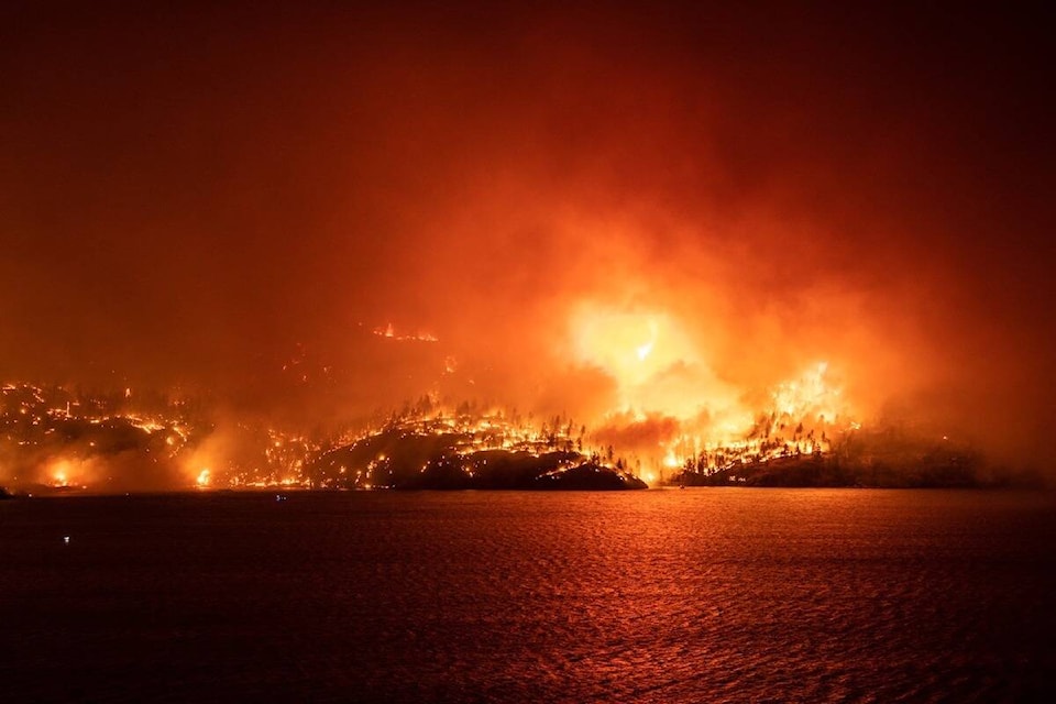
Flames can now been seen from across Okanagan Lake. A helicopter is dropping water on the blaze pic.twitter.com/zgBFWevN6K
— Jordy Cunningham (@CunninghamJordy) August 18, 2023
Original
The McDougall Creek wildfire in West Kelowna has exploded to 6,800 hectares and remains highly visible, according to BC Wildfire Services.
Throughout Thursday night and into Friday morning, the blaze spread east, over the mountains towards Okanagan Lake.
The fire is displaying rank 5 fire behaviour, meaning it is growing and spreading rapidly. BC Wildfire Services have 21 fire personnel and three helicopters battling the blaze but visibility has posed as a challenge.
Some structures were lost throughout the night and in the early morning, Central Okanagan Emergency Operations has confirmed, but could not speak to numbers.
As of right now, 2,462 properties are under evacuation order and 4,801 properties are under evacuation alert for the McDougall Creek Wildfire.
A helicopter is grabbing water from Okanagan Lake to help battle the blaze in #WestKelowna pic.twitter.com/5LCN9syYkB
— Jordy Cunningham (@CunninghamJordy) August 18, 2023
BC Wildfire and the Fire Departments have been working overnight in several areas through Kelowna, West Kelowna and Westside Road in the RDCO.
— Central Ok Emergency (@CO_Emerg) August 18, 2023
For evacuation orders and alerts, go to https://t.co/Er29JVt51A
Evacuees are asked to register online or visit Prospera Place in downtown Kelowna.
More to come.
READ MORE: New wildfire spotted in Lake Country
READ MORE: OKANAGAN WILDFIRES: What you need to know for Friday, Aug. 18
@cunninghamjordy
jordy.cunningham@kelownacapnews.com
Like us on Facebook and follow us on Twitter and subscribe to our daily and subscribe to our daily newsletter.