UPDATE 1 p.m. May 4
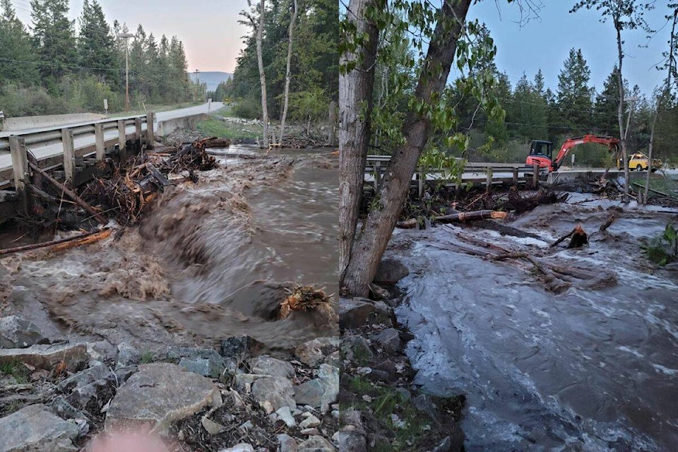
The bridge crossing Whiteman’s creek continues to be monitored to remove log jams.
Flow remains high and the Ministry of Transportation and Infrastructure will continue to assist in monitoring duties and determining the safety of the crossing. The bridge is currently in single lane alternating traffic state due to water levels impacting south bound lanes.
Okanagan Indian Band crews continue to plan and action mitigation efforts on both sides of the creek in the flooding area.
“Mitigation efforts have been difficult with surges occurring. Crews have noted some flood water penetration along Falcon Ave as well as over land water on the south side of the creek,” the band said.
Ground instabilities have been causing tree falls in the area making creating hazards for crews working in the area.
OKIB also continues to order sand for sandbags as well as other mitigation methods and maintain a sandbagging station. Crews on site at the flooding area also have multiple pieces of earth moving machinery to expediate mitigation efforts.
OKIB will continue to monitor the freshet flooding situation and provide updates as possible.
Ministry of Forest staff are also conducting monitoring activities in the watersheds above Whiteman’s Creek to keep the OKIB Emergecy Operations Centre well informed.
…………………………
UPDATE: 10 p.m.
As of 9 p.m., the Okanagan Indian Band is recommending that all non-emergency personnel leave the evacuation order area.
Flood waters have been undermining land and undercutting large trees in the area, causing uncontrolled falls.
Despite a reduction in flow levels during the day on Wednesday, the OKIB and emergency operations are reminding residents in the area, that conditions can change rapidly, including unstable land, flood water flow levels and water depth.
“The OKIB is reminding evacuated residents who are still residing in the evacuation order area, that staying in the vicinity is at your own risk to your life and health,” stated the OKIB.
_____
UPDATE: 7:30 p.m. May 3
More properties are under an evacuation order due to the flooding of Whiteman’s Creek.
Wednesday afternoon the Okanagan Indian Band (OKIB) said an evacuation order is in effect for beach front properties between Raven Road and No. 209 Saskatoon Road.
The OKIB says the evacuation order has been issued “due to immediate danger to life safety caused by flooding of Whiteman’s Creek.”
Members of the OKIB, the local fire department, bylaw and other applicable agencies will be expediting this action.
The OKIB has released instructions for what residents should do if their properties are under an evacuation order.
…………………………………….
Original:
Flooding has forced even more Westside Road residents to evacuate and put additional homes on alert.
Okanagan Indian Band (OKIB) issued an additional evacuation order Tuesday, May 2 at 9 p.m. The extended order is for Parker Cove residents on Falcon Avenue in units 139-160, 196-223 and 225-329, as well as residents south of Whiteman’s Creek on Raven Road along Saskatoon Road.
Meanwhile an evacuation alert was issued May 2 at 10 p.m. for Parker Cove residents on Grouse Avenue, Deer Street, Elk Street, Falcon Avenue and Lakeshore Drive.
• Grouse Avenue: 240-283, 291-320, 334-349
• Deer Street: 115-130
• Elk Street: 89-114
• Lakeshore Drive: 34-53
• Falcon Avenue: 224
OKIB previously issued evacuation orders May 2 for Parker Cove residents south of Falcon Avenue adjacent to Whiteman’s Creek and #161-195 Falcon Avenue including 54 and 55.
The order is “due to immediate danger to life safety caused by flooding of Whiteman’s Creek,” according to the band.
Falcon Road resident Bob Grant was watching the water flood down his street Tuesday morning. He said it’s the worst flooding he’s seen in the more than 20 years he’s lived there.
“We had a flood in 2017 but it didn’t come out to the road,” he said.
Grant said residents evacuated Tuesday morning but some of them have come back to sandbag around their properties. Some residents could be seen driving through the water and sandbagging around noon Tuesday.
“They’re not supposed to but they’re doing it,” Grant said.
So far Grant’s home is OK, but “it depends on what happens tonight,” he said, explaining he watched the water encroach further up the street in a matter of hours this morning.
OKIB continues to monitor the creek systems on reserve during the flooding. Crews are continuing to mitigate damage to infrastructure and homes in the effect areas.
“The flooding event we are experiencing currently can be described as a 200-year event given current water levels and flow in the Whiteman’s area,” the band said.
The watersheds continue to be monitored via helicopter by emergency management and climate resilience forestry personnel to gain greater situational awareness.
“OKIB will continue its 24-hour monitoring of creeks and effected areas on reserve and residents should be prepared to evacuate as this is a fast evolving event.”
Residents evacuated are advised to:
• Follow the travel route provided and register at: #8 Bonneau Road, New Horizons building.
• If you need transportation assistance from the area, advise the person providing this notice or call: 250-241-5809
• Shut off all gas and electrical appliances, other than refrigerators and freezers.
• Close all windows and doors.
• Close gates (latch) but do not lock.
• Gather your family and, if you have room, take a neighbour or someone needing transportation. Do not use more vehicles then you have to.
• Take critical items (medicine, purse, wallet, and keys) only if they are immediately available. Take pets in pet kennels or on leash.
• Do not use the telephone unless you need emergency service.
Whiteman’s Creek bridge is still open, however the OKIB says there may be periodic traffic interruptions while crews clear debris in the creek near the bridge to mitigate risk to the structure.
The Regional District of Central Okanagan (RDCO) is making sandbags available to affected residents at area fire departments.
“Isolated flooding events have occurred in the Central Okanagan West Electoral Area near high flowing creeks, particularly in areas impacted by the White Rock Lake wildfire,” the RDCO said. “We are closely monitoring electoral areas and have made sandbags available in anticipation of possible flooding.”
Property owners are responsible for having an emergency plan and the tools and equipment needed to protect their properties from flooding.
Residents can pick up sandbags at area fire departments:
• Ellison Fire Department — Station 61 — 4411 Old Vernon Road
• Joe Rich Fire Rescue — Station 52 — 6550 Goudie Road
Self-serve sand and bags are available at:
• Joe Rich Fire Rescue — Station 51 — 11481 Highway 33
• North Westside Fire Rescue — Station 101 — Killiney Beach main hall, 514 Udell Road; and Station 102 — Westside Road hall, 7355 Westside Road North
• Wilson’s Landing Fire Department — 2396 Westside Road
Property owners are also encouraged to check ditches and driveway access culverts to ensure proper runoff. Residents can contact AIM Roads at 1-866-222-4204 with any concerns.
For updates, visit OKIB Facebook page or okib.ca.
READ MORE: Flood risk drives Westside Road delays, lake debris
READ MORE: Crews rescue boat in distress on Okanagan Lake
@VernonNews
newsroom@vernonmorningstar.com
Like us on Facebook and follow us on Twitter