UPDATE: 9:20 p.m.
Hundreds of more homes have been ordered evacuated on Wednesday evening due to the growing White Rock Lake wildfire.
The Columbia-Shuswap Regional District has issued an evacuation order for the entire community of Falkland, including the Cedar Creek and Pinaus Lake areas. In addition to the order, the evacuation alert in the area has been expanded to include Silver Creek, Deep Creek and Gardom Lake.
Falkland and Cedar Hill - an EVACUATION ORDER has been issued by the CSRD on August 4 at 20:30 Hours. See the CSRD website at: https://t.co/2EeQXkl721 https://t.co/jZzAx1pI93 pic.twitter.com/IhLPM3onJi
— Shuswap Emergency Program (@shuswapemerg) August 5, 2021
The Columbia-Shuswap Regional District says the order applies to all addresses within Falkland, Cedar Creek and Pinaus Lake, in the southwestern portion of Electoral Area D.
Properties from 6547 to 6899 Six Mile Creek Road are not impacted by the order.
IMPORTANT INFO: ONLY FALKLAND IS UNDER EVACUATION ORDER. Please read your ENTIRE Alertable notification. You will see the actual ORDER and ALERT map for the area is included.
— Shuswap Emergency Program (@shuswapemerg) August 5, 2021
If you are Evacuating, please see this Evacuation Routes Map for appropriate routes out of Falkland. pic.twitter.com/KSG8C4iwzy
The Okanagan Indian Band has expanded its existing evacuation order for addresses located between 11497 Smith Crescent and 11071 Westside Road/Mud Hole Road, westward to the reserve boundary.
The following streets are included in the order:
- Stump Rd.
- Bonneau Rd.
- Black Gulch Rd.
- Smith Cres Jack Rd.
- Williams Lane
- Alexander Rd.
- Jack Ln.
- Tuma’s Rd.
- Westside Rd. (11100 – 11600 block)
- Battleplace Rd.
- Su?q’im Rd.
- Louis Rd.
- Marchand Rd.
- Royal Rd.
- Eagle Nest Rd.
- Mary Ann’s Rd.
- Whitetail Rd.
- Whitetail Way
- Six Mile Creek Rd.
- Imtil Rd.
- Victoria Rd.
- Mini-Shadows Rd.
- Siwash Creek Rd.
The Thompson-Nicola Regional District issued an evacuation order for 271 more homes near Westwold and Monte Creek.
The order includes the following addresses:
- 5644 to 5737 Back Rd;
- 4732 to 4754 Buff Frontage Rd;
- 6607 to 6725 Bulman Rd;
- 6539 Douglas Lake Rd;
- 3526 to 6975 Hwy 97;
- 4120 to 4249 Kristianson Rd;
- 3787 to 3862 Mill Rd;
- 3754 to 3903 Monte Lake Rd;
- 3928 to 5070 Paxton Valley Rd;
- 6639 Pringle Rd;
- 6572 and 6593 Service Rd;
- 4294 Strong Rd;
- 5469 to 5545 Westlund Rd;
- 6365 to 6504 Westwold Station Rd; and
- any properties within the boundary outlined on map below.
The TNRD EOC has issued an Evacuation Order for 271 properties in the vicinity of Westwold/Monte Lake due to threat from the White Rock Lake Wildfire. #BCWildfirehttps://t.co/IGa22slEDI pic.twitter.com/KD0nkqYn4x
— TNRD (@TNRD) August 5, 2021
To the south in the Regional District of Central Okanagan, crews continue to monitor the situation and existing evacuation orders and alerts will remain in place overnight.
”Fire activity increased north & east of us but remains more stable in our area,” said the Central Okangan Emergency Operations Centre in a Wednesday evening tweet.
The EOC & BC Wildfire are monitoring fire in Electoral Area West. Fire activity increased north & east of us but remains more stable in our area. Existing evac order & alert remain overnight. RCMP will patrol in evacuated areas. Next update tomorrow unless conditions change. pic.twitter.com/ARdotSmaRB
— Central Ok Emergency (@CO_Emerg) August 5, 2021
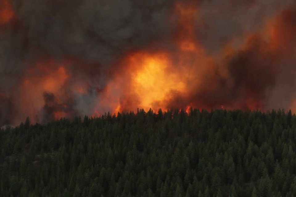
As of noon on Wednesday, the White Rock Lake wildfire is at an estimated 32,500 hectares in size and 8.5 kilometres away from Westside Road.
UPDATE: 8:30 p.m.
Forecasted wind is set to increase activity in the White Rock Lake wildfire beginning tomorrow, Aug. 5, says the BC Wildfire Service.
Please reach out directly to your local government authority for the most up-to-date and accurate information regarding Evacuation Alerts and Orders.
— BC Wildfire Service (@BCGovFireInfo) August 5, 2021
To listen to today’s operational update: https://t.co/uso624C13G
Sustained 25 km/h southwesterly winds, gusting up to 40 km/h, are forecast to begin as early as tomorrow afternoon.
“[The] public is urged to maintain heightened awareness of the situation over the next 48 hours, and should be prepared for a potential evacuation alert or order,” said the wildfire service in a Wednesday evening tweet.
Evacuation orders remain in effect for almost 700 properties across five separate areas: Regional District of Central Okanagan, Thompson Nicola Regional District, Columbia-Shuswap Regional District, Regional District of North Okanagan and Okanagan Indian Band lands. Thousands remain on evacuation alert.
As of noon on Wednesday, the fire is at an estimated 32,500 hectares in size and 8.5 kilometres away from Westside Road.
UPDATE: 2:20 p.m.
The Regional District of Central Okanagan (RDCO) is urging residents of the 2,400 homes under evacuation alert near the growing White Rock Lake wildfire to prepare for potential evacuations.
Emergency officials say the fire is showing “aggressive behaviour” and residents on alert should be prepared to leave on short notice if conditions worsen.
The RDCO’s alert applies to properties south of Westshore Estates to the Bear Lake Main Forest Service Road intersection just north of Traders Cove. The alert area also includes all public lands located north of Bear and Esperon Forest Service Road. The area is restricted to local traffic only.
Currently, evacuation orders remain in effect for 544 properties in the Central Okanagan, 85 properties in the Thompson-Nicola Regional District, 10 in the Columbia-Shuswap Regional District, 32 in the Regional District of North Okanagan and below the Whiteman Creek drainage including Parker Cove and Whiteman subdivisions on OKIB land. Thousands more in those areas are also on evacuation alert.
The fire is still estimated at 32,500 hectares in size and sits 8.5 kilometres west of Westside Road.
ORIGINAL:
Winds blew the White Rock Lake wildfire toward Okanagan Indian Band land yesterday but heavy smoke hindered accurate detection.
Clearer conditions yesterday allowed BC Wildfire Services (BCWS) to better detect the fire perimeter. As of last night, the fire burning at around 32,500 hectares is about 8.5 kilometres west of Westside Road.
But, the decrease in smoke also allowed for aircraft to join the firefighting efforts.
“Currently the trajectory of the fire has continued on the ridge between Whiteman Main and Bouleau Road,” a 6:30 p.m. update from Okanagan Indian Band said, noting more accurate mapping depicting the fire’s position is to come.
“Structural protection teams have worked all day to get all the mass water delivery systems set up and are standing by should protection action become necessary.”
Westside Road remains closed to northbound traffic at the evacuation zone. DriveBC says this is between Pinecrest and Six Mile Creek roads for 8.4 km. There is no estimated time of reopening.
The closure, OKIB said, allows BC Wildfire crews to set up the fire suppression systems.
“The road closure will likely continue for the duration of the evacuation order time period.”
BCWS said the benefits of the last rainfall are gone and temperatures are expected to reach the mid-30s with humidity.
Forecasted winds may impact the fire activity beginning as early as Thursday afternoon, BCWS said.
Evacuation orders are still in effect for 544 properties in the Central Okanagan (RDCO), 85 properties in the Thompson-Nicola Regional District, 10 in the Columbia-Shuswap Regional District, 32 in the Regional District of North Okanagan and below the Whiteman Creek drainage including Parker Cove and Whiteman subdivisions on OKIB land. Alerts are still in effect for thousands more.
The City of Armstrong and Township of Spallumcheen have opened the IPE grounds to aid evacuees.
A temporary camp will be set up for 200-plus provincial wildfire fighters and support staff at Kin Race Track in Vernon for the next four to six weeks. Members of the public are asked to respect the privacy of those staying there and use other municipal facilities for recreation purposes.
READ MORE: Temporary camp set up for 200-plus firefighters at Kin Race Track in Vernon
“The City of Vernon welcomes BC Wildfire Service to our community and would like to thank all firefighters and support personnel who are working tirelessly across the province in response to wildfire activities taking place,” a statement from the city reads.
O’Keefe Ranch in Spallumcheen has opened its grounds to campers with their own equipment, while the North Okanagan Therapeutic Riding Association is offering space for evacuated animals. Those with valid evacuee paperwork and camping gear can call the O’Keefe Ranch at 250-542-7868 or reach out on Facebook if in need of someplace to stay. Anyone in need of NOTRA’s facilities due to wildfire evacuation orders can contact 250-549-0105 or by email at notra1984@gmail.com.
Eleven helicopters, 10 danger tree assessors, 136 firefighters, 43 pieces of heavy equipment and 14 support staff are assigned to the fire.
More than 100 structure protection personnel from 25 different fire departments are prepared to defend properties in Westwold, Falkland, Cedar Hills, Pinaus Lake and communities along Westside Road 24-7.
READ MORE: Safe haven for animals evacuated from nearby wildfires set up at O’Keefe Ranch
READ MORE: Evacuees returning home after a wildfire should throw out garden food, drain pools
@VernonNews
newsroom@vernonmorningstar.com
Like us on Facebook and follow us on Twitter.